Doggerland was an area of land, now submerged beneath the southern North Sea, that connected Britain to continental Europe. It was flooded by rising sea levels around 6500–6200 BC. Geological surveys have suggested that it stretched from where Britain’s east coast is now to the present-day Netherlands, western coast of Germany, and the peninsula of Jutland. It was probably a rich habitat with human habitation in the Mesolithic period, although rising sea levels gradually reduced it to low-lying islands before it was finally submerged, possibly, some say, following a tsunami caused by the Storegga Slide.
The archaeological potential of the area was first identified in the early 20th century, and interest intensified in 1931 when a fishing trawler operating east of the Wash dragged up a barbed antler point that was subsequently dated to a time when the area was tundra. Vessels have dragged up remains of mammoths, lions and other animals, as well as prehistoric tools and weapons.
Doggerland was named in the 1990s, after the Dogger Bank, which in turn was named after the 17th century Dutch fishing boats called ‘doggers’ [Source: Wikipedia].
20,000 BC
Vast ice sheets covered much of the area.
15.000 BC
The climate began to warm and, as the ice sheets melted, humans started to repopulate the area.
13.000 BC
The warming was suddenly interrupted.
10.000 BC
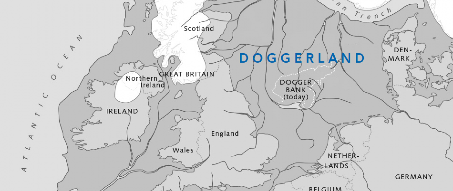
We can see from research by archaeologists like Bryony Coles and Vince Gaffney that a map of north western Europe would have looked something like the map below.
Doggerland had a rich landscape of hills, rivers and lakes and a coastline comprising lagoons, marshes and beaches. It had woodlands of oak, elm, birch, willow, alder, hazel and pine. It was home to horses, aurochs, deer, elks and wild pigs. Waterfowl, otters and beavers abounded in wetland areas and the seas, lakes and rivers teemed with fish. It was probably the richest hunting and fishing ground in Europe at the time and had an important influence on the course of prehistory in north western Europe as maritime and river-based societies adapted to this environment.
8.500 BC
Then warming accelerated, the ice sheets rapidly melted and sea levels rose. Most of Doggerland was submerged beneath the North Sea and Britain was cut off from the European mainland.
5.000 BC
The average global temperatures reached their maximum level, being 1 to 2°C warmer than they are today The island where the current Dogger Bank is situated was lost under the sea.
1931
A trawler named “Colinda” hauled up a lump of peat whilst fishing near the Ower Bank, 25 miles off the English coast. Doggerland was re-discovered.
2019
Doggerland Offshore was established.

